A PHP Error was encountered
Severity: 8192
Message: Creation of dynamic property CI_URI::$config is deprecated
Filename: core/URI.php
Line Number: 101
Backtrace:
File: /home3/aiondc9y/public_html/demo/shaktiorg/index.php
A PHP Error was encountered
Severity: 8192
Message: Creation of dynamic property CI_Router::$uri is deprecated
Filename: core/Router.php
Line Number: 127
Backtrace:
File: /home3/aiondc9y/public_html/demo/shaktiorg/index.php
A PHP Error was encountered
Severity: 8192
Message: Creation of dynamic property Target_community::$benchmark is deprecated
Filename: core/Controller.php
Line Number: 82
Backtrace:
File: /home3/aiondc9y/public_html/demo/shaktiorg/index.php
A PHP Error was encountered
Severity: 8192
Message: Creation of dynamic property Target_community::$hooks is deprecated
Filename: core/Controller.php
Line Number: 82
Backtrace:
File: /home3/aiondc9y/public_html/demo/shaktiorg/index.php
A PHP Error was encountered
Severity: 8192
Message: Creation of dynamic property Target_community::$config is deprecated
Filename: core/Controller.php
Line Number: 82
Backtrace:
File: /home3/aiondc9y/public_html/demo/shaktiorg/index.php
A PHP Error was encountered
Severity: 8192
Message: Creation of dynamic property Target_community::$log is deprecated
Filename: core/Controller.php
Line Number: 82
Backtrace:
File: /home3/aiondc9y/public_html/demo/shaktiorg/index.php
A PHP Error was encountered
Severity: 8192
Message: Creation of dynamic property Target_community::$utf8 is deprecated
Filename: core/Controller.php
Line Number: 82
Backtrace:
File: /home3/aiondc9y/public_html/demo/shaktiorg/index.php
A PHP Error was encountered
Severity: 8192
Message: Creation of dynamic property Target_community::$uri is deprecated
Filename: core/Controller.php
Line Number: 82
Backtrace:
File: /home3/aiondc9y/public_html/demo/shaktiorg/index.php
A PHP Error was encountered
Severity: 8192
Message: Creation of dynamic property Target_community::$exceptions is deprecated
Filename: core/Controller.php
Line Number: 82
Backtrace:
File: /home3/aiondc9y/public_html/demo/shaktiorg/index.php
A PHP Error was encountered
Severity: 8192
Message: Creation of dynamic property Target_community::$router is deprecated
Filename: core/Controller.php
Line Number: 82
Backtrace:
File: /home3/aiondc9y/public_html/demo/shaktiorg/index.php
A PHP Error was encountered
Severity: 8192
Message: Creation of dynamic property Target_community::$output is deprecated
Filename: core/Controller.php
Line Number: 82
Backtrace:
File: /home3/aiondc9y/public_html/demo/shaktiorg/index.php
A PHP Error was encountered
Severity: 8192
Message: Creation of dynamic property Target_community::$security is deprecated
Filename: core/Controller.php
Line Number: 82
Backtrace:
File: /home3/aiondc9y/public_html/demo/shaktiorg/index.php
A PHP Error was encountered
Severity: 8192
Message: Creation of dynamic property Target_community::$input is deprecated
Filename: core/Controller.php
Line Number: 82
Backtrace:
File: /home3/aiondc9y/public_html/demo/shaktiorg/index.php
A PHP Error was encountered
Severity: 8192
Message: Creation of dynamic property Target_community::$lang is deprecated
Filename: core/Controller.php
Line Number: 82
Backtrace:
File: /home3/aiondc9y/public_html/demo/shaktiorg/index.php
A PHP Error was encountered
Severity: 8192
Message: Creation of dynamic property Target_community::$db is deprecated
Filename: core/Loader.php
Line Number: 396
Backtrace:
File: /home3/aiondc9y/public_html/demo/shaktiorg/index.php
A PHP Error was encountered
Severity: 8192
Message: Creation of dynamic property CI_DB_mysqli_driver::$failover is deprecated
Filename: database/DB_driver.php
Line Number: 371
Backtrace:
File: /home3/aiondc9y/public_html/demo/shaktiorg/index.php
A PHP Error was encountered
Severity: 8192
Message: Creation of dynamic property Target_community::$email is deprecated
Filename: core/Loader.php
Line Number: 1283
Backtrace:
File: /home3/aiondc9y/public_html/demo/shaktiorg/index.php
A PHP Error was encountered
Severity: 8192
Message: Return type of CI_Session_files_driver::open($save_path, $name) should either be compatible with SessionHandlerInterface::open(string $path, string $name): bool, or the #[\ReturnTypeWillChange] attribute should be used to temporarily suppress the notice
Filename: drivers/Session_files_driver.php
Line Number: 132
Backtrace:
File: /home3/aiondc9y/public_html/demo/shaktiorg/index.php
A PHP Error was encountered
Severity: 8192
Message: Return type of CI_Session_files_driver::close() should either be compatible with SessionHandlerInterface::close(): bool, or the #[\ReturnTypeWillChange] attribute should be used to temporarily suppress the notice
Filename: drivers/Session_files_driver.php
Line Number: 294
Backtrace:
File: /home3/aiondc9y/public_html/demo/shaktiorg/index.php
A PHP Error was encountered
Severity: 8192
Message: Return type of CI_Session_files_driver::read($session_id) should either be compatible with SessionHandlerInterface::read(string $id): string|false, or the #[\ReturnTypeWillChange] attribute should be used to temporarily suppress the notice
Filename: drivers/Session_files_driver.php
Line Number: 168
Backtrace:
File: /home3/aiondc9y/public_html/demo/shaktiorg/index.php
A PHP Error was encountered
Severity: 8192
Message: Return type of CI_Session_files_driver::write($session_id, $session_data) should either be compatible with SessionHandlerInterface::write(string $id, string $data): bool, or the #[\ReturnTypeWillChange] attribute should be used to temporarily suppress the notice
Filename: drivers/Session_files_driver.php
Line Number: 237
Backtrace:
File: /home3/aiondc9y/public_html/demo/shaktiorg/index.php
A PHP Error was encountered
Severity: 8192
Message: Return type of CI_Session_files_driver::destroy($session_id) should either be compatible with SessionHandlerInterface::destroy(string $id): bool, or the #[\ReturnTypeWillChange] attribute should be used to temporarily suppress the notice
Filename: drivers/Session_files_driver.php
Line Number: 317
Backtrace:
File: /home3/aiondc9y/public_html/demo/shaktiorg/index.php
A PHP Error was encountered
Severity: 8192
Message: Return type of CI_Session_files_driver::gc($maxlifetime) should either be compatible with SessionHandlerInterface::gc(int $max_lifetime): int|false, or the #[\ReturnTypeWillChange] attribute should be used to temporarily suppress the notice
Filename: drivers/Session_files_driver.php
Line Number: 358
Backtrace:
File: /home3/aiondc9y/public_html/demo/shaktiorg/index.php
A PHP Error was encountered
Severity: Warning
Message: ini_set(): Session ini settings cannot be changed after headers have already been sent
Filename: Session/Session.php
Line Number: 282
Backtrace:
File: /home3/aiondc9y/public_html/demo/shaktiorg/index.php
A PHP Error was encountered
Severity: Warning
Message: session_set_cookie_params(): Session cookie parameters cannot be changed after headers have already been sent
Filename: Session/Session.php
Line Number: 289
Backtrace:
File: /home3/aiondc9y/public_html/demo/shaktiorg/index.php
A PHP Error was encountered
Severity: Warning
Message: ini_set(): Session ini settings cannot be changed after headers have already been sent
Filename: Session/Session.php
Line Number: 304
Backtrace:
File: /home3/aiondc9y/public_html/demo/shaktiorg/index.php
A PHP Error was encountered
Severity: Warning
Message: ini_set(): Session ini settings cannot be changed after headers have already been sent
Filename: Session/Session.php
Line Number: 314
Backtrace:
File: /home3/aiondc9y/public_html/demo/shaktiorg/index.php
A PHP Error was encountered
Severity: Warning
Message: ini_set(): Session ini settings cannot be changed after headers have already been sent
Filename: Session/Session.php
Line Number: 315
Backtrace:
File: /home3/aiondc9y/public_html/demo/shaktiorg/index.php
A PHP Error was encountered
Severity: Warning
Message: ini_set(): Session ini settings cannot be changed after headers have already been sent
Filename: Session/Session.php
Line Number: 316
Backtrace:
File: /home3/aiondc9y/public_html/demo/shaktiorg/index.php
A PHP Error was encountered
Severity: Warning
Message: ini_set(): Session ini settings cannot be changed after headers have already been sent
Filename: Session/Session.php
Line Number: 317
Backtrace:
File: /home3/aiondc9y/public_html/demo/shaktiorg/index.php
A PHP Error was encountered
Severity: Warning
Message: ini_set(): Session ini settings cannot be changed after headers have already been sent
Filename: Session/Session.php
Line Number: 375
Backtrace:
File: /home3/aiondc9y/public_html/demo/shaktiorg/index.php
A PHP Error was encountered
Severity: Warning
Message: session_set_save_handler(): Session save handler cannot be changed after headers have already been sent
Filename: Session/Session.php
Line Number: 110
Backtrace:
File: /home3/aiondc9y/public_html/demo/shaktiorg/index.php
A PHP Error was encountered
Severity: Warning
Message: session_start(): Session cannot be started after headers have already been sent
Filename: Session/Session.php
Line Number: 143
Backtrace:
File: /home3/aiondc9y/public_html/demo/shaktiorg/index.php
A PHP Error was encountered
Severity: 8192
Message: Creation of dynamic property Target_community::$session is deprecated
Filename: core/Loader.php
Line Number: 1283
Backtrace:
File: /home3/aiondc9y/public_html/demo/shaktiorg/index.php
A PHP Error was encountered
Severity: 8192
Message: Creation of dynamic property Target_community::$form_validation is deprecated
Filename: core/Loader.php
Line Number: 1283
Backtrace:
File: /home3/aiondc9y/public_html/demo/shaktiorg/index.php
A PHP Error was encountered
Severity: 8192
Message: Creation of dynamic property Target_community::$CommonModel is deprecated
Filename: core/Loader.php
Line Number: 358
Backtrace:
File: /home3/aiondc9y/public_html/demo/shaktiorg/index.php
A PHP Error was encountered
Severity: 8192
Message: Creation of dynamic property CI_Loader::$load is deprecated
Filename: core/Loader.php
Line Number: 931
Backtrace:
File: /home3/aiondc9y/public_html/demo/shaktiorg/application/controllers/Target_community.php
File: /home3/aiondc9y/public_html/demo/shaktiorg/index.php
A PHP Error was encountered
Severity: 8192
Message: Creation of dynamic property CI_Loader::$benchmark is deprecated
Filename: core/Loader.php
Line Number: 931
Backtrace:
File: /home3/aiondc9y/public_html/demo/shaktiorg/application/controllers/Target_community.php
File: /home3/aiondc9y/public_html/demo/shaktiorg/index.php
A PHP Error was encountered
Severity: 8192
Message: Creation of dynamic property CI_Loader::$hooks is deprecated
Filename: core/Loader.php
Line Number: 931
Backtrace:
File: /home3/aiondc9y/public_html/demo/shaktiorg/application/controllers/Target_community.php
File: /home3/aiondc9y/public_html/demo/shaktiorg/index.php
A PHP Error was encountered
Severity: 8192
Message: Creation of dynamic property CI_Loader::$config is deprecated
Filename: core/Loader.php
Line Number: 931
Backtrace:
File: /home3/aiondc9y/public_html/demo/shaktiorg/application/controllers/Target_community.php
File: /home3/aiondc9y/public_html/demo/shaktiorg/index.php
A PHP Error was encountered
Severity: 8192
Message: Creation of dynamic property CI_Loader::$log is deprecated
Filename: core/Loader.php
Line Number: 931
Backtrace:
File: /home3/aiondc9y/public_html/demo/shaktiorg/application/controllers/Target_community.php
File: /home3/aiondc9y/public_html/demo/shaktiorg/index.php
A PHP Error was encountered
Severity: 8192
Message: Creation of dynamic property CI_Loader::$utf8 is deprecated
Filename: core/Loader.php
Line Number: 931
Backtrace:
File: /home3/aiondc9y/public_html/demo/shaktiorg/application/controllers/Target_community.php
File: /home3/aiondc9y/public_html/demo/shaktiorg/index.php
A PHP Error was encountered
Severity: 8192
Message: Creation of dynamic property CI_Loader::$uri is deprecated
Filename: core/Loader.php
Line Number: 931
Backtrace:
File: /home3/aiondc9y/public_html/demo/shaktiorg/application/controllers/Target_community.php
File: /home3/aiondc9y/public_html/demo/shaktiorg/index.php
A PHP Error was encountered
Severity: 8192
Message: Creation of dynamic property CI_Loader::$exceptions is deprecated
Filename: core/Loader.php
Line Number: 931
Backtrace:
File: /home3/aiondc9y/public_html/demo/shaktiorg/application/controllers/Target_community.php
File: /home3/aiondc9y/public_html/demo/shaktiorg/index.php
A PHP Error was encountered
Severity: 8192
Message: Creation of dynamic property CI_Loader::$router is deprecated
Filename: core/Loader.php
Line Number: 931
Backtrace:
File: /home3/aiondc9y/public_html/demo/shaktiorg/application/controllers/Target_community.php
File: /home3/aiondc9y/public_html/demo/shaktiorg/index.php
A PHP Error was encountered
Severity: 8192
Message: Creation of dynamic property CI_Loader::$output is deprecated
Filename: core/Loader.php
Line Number: 931
Backtrace:
File: /home3/aiondc9y/public_html/demo/shaktiorg/application/controllers/Target_community.php
File: /home3/aiondc9y/public_html/demo/shaktiorg/index.php
A PHP Error was encountered
Severity: 8192
Message: Creation of dynamic property CI_Loader::$security is deprecated
Filename: core/Loader.php
Line Number: 931
Backtrace:
File: /home3/aiondc9y/public_html/demo/shaktiorg/application/controllers/Target_community.php
File: /home3/aiondc9y/public_html/demo/shaktiorg/index.php
A PHP Error was encountered
Severity: 8192
Message: Creation of dynamic property CI_Loader::$input is deprecated
Filename: core/Loader.php
Line Number: 931
Backtrace:
File: /home3/aiondc9y/public_html/demo/shaktiorg/application/controllers/Target_community.php
File: /home3/aiondc9y/public_html/demo/shaktiorg/index.php
A PHP Error was encountered
Severity: 8192
Message: Creation of dynamic property CI_Loader::$lang is deprecated
Filename: core/Loader.php
Line Number: 931
Backtrace:
File: /home3/aiondc9y/public_html/demo/shaktiorg/application/controllers/Target_community.php
File: /home3/aiondc9y/public_html/demo/shaktiorg/index.php
A PHP Error was encountered
Severity: 8192
Message: Creation of dynamic property CI_Loader::$db is deprecated
Filename: core/Loader.php
Line Number: 931
Backtrace:
File: /home3/aiondc9y/public_html/demo/shaktiorg/application/controllers/Target_community.php
File: /home3/aiondc9y/public_html/demo/shaktiorg/index.php
A PHP Error was encountered
Severity: 8192
Message: Creation of dynamic property CI_Loader::$email is deprecated
Filename: core/Loader.php
Line Number: 931
Backtrace:
File: /home3/aiondc9y/public_html/demo/shaktiorg/application/controllers/Target_community.php
File: /home3/aiondc9y/public_html/demo/shaktiorg/index.php
A PHP Error was encountered
Severity: 8192
Message: Creation of dynamic property CI_Loader::$session is deprecated
Filename: core/Loader.php
Line Number: 931
Backtrace:
File: /home3/aiondc9y/public_html/demo/shaktiorg/application/controllers/Target_community.php
File: /home3/aiondc9y/public_html/demo/shaktiorg/index.php
A PHP Error was encountered
Severity: 8192
Message: Creation of dynamic property CI_Loader::$form_validation is deprecated
Filename: core/Loader.php
Line Number: 931
Backtrace:
File: /home3/aiondc9y/public_html/demo/shaktiorg/application/controllers/Target_community.php
File: /home3/aiondc9y/public_html/demo/shaktiorg/index.php
A PHP Error was encountered
Severity: 8192
Message: Creation of dynamic property CI_Loader::$CommonModel is deprecated
Filename: core/Loader.php
Line Number: 931
Backtrace:
File: /home3/aiondc9y/public_html/demo/shaktiorg/application/controllers/Target_community.php
File: /home3/aiondc9y/public_html/demo/shaktiorg/index.php
Welcome To Shakti organisation (SSCSO)
Target Community
Rayagada District is one of 30 Districts of Odisha. It is situated between 180 54” and 200 00 North Latitude, 820 54” and 840 02 East Longitude. It is bounded by Gajapati District in the East, Kalahandi District in the West, Kandamal in the North and Koraput District and the state of Andra Pradesh in the South. It has an area of 7,584.7 Sq. Kms. The district is characterised by a rugged terrain of hills and thick forests. The forest area covers 4785.36 Sq.K.M. out of which 777.27 Sq.K.M. is reserved forest, protected by Govt. The prominent geomorphic features of the district are structural and denudational hills Intermontane valleys and flood plaints of the Vamsadhara and Nagavalli rivers.
Demography
It has a population of 961,959 (469,672 men and 492,287 women) as per the 2011 census. The population density is per square km is 136 as per 2011 census. The district has predominately a rural population.
Administrative setup
The District is divided into 2 Sub-divisions, 11 Tahasils, 11 Panchayat samities, 1 Municipality, 2 Notified Area Councils and 171 Gram Panchayats having 2667 villages.
Socio-economic status
The District as a whole is considered one of the most underdeveloped areas of Odisha. The Planning Commission of the country identified it as one of the bottom 100 most backward and under developed Districts of India.
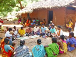
It is largely inhabited by indigenous tribes, living in small groups in the inaccessible forest and hills. 32% of food producing land is with tribals, 60% of this land is with landlords and middleman. Inaccessibility and inequitable land holding have resulted in a dearth of basic requirements, leaving the tribes vulnerable to food insecurity and health hazards. Mal nutrition is common among pregnant women, lactating mothers and children under six years of age.
In education sector, Rayagada District has an average literacy rate of 50.88 percent: but the male literacy rate of 62.61% masks the abysmally low female literacy rate which stands at only 39.87%.
The District is the homeland of various tribal communities with their sub-tribes, who are considered an under privileged section of society. The kondhas Souras
Only 30% of the total geographical area of the district is available for cultivation. Cultivation is generally confined to the monsoon season (Kharif) and depends upon rainfall. Red soils and alluvial deposits are the predominant soil types in the District. The total irrigated area of the District is only 322.51 sq.km, which is only 19.3 % of the net cultivated area. No uniform cropping pattern is followed in the district. Shifting or Podu cultivation is practiced on high hill slopes by the tribal people.
Poverty Status
For a sizeable part of the population, Poverty has become hereditary. The poverty level is reducing but at a slow pace. Though the number of very poor is decreasing, the percentage is quite su bstantial. It is the conclusion derived from a three-decade tracking of poor households in rural area. The researcher’s claims that those who are chronically poor pass on poverty to their next generation. What is more, people residing in tribal and forested areas are likely to remain poor forever. The numerous Government poverty alleviation programmes are inadequate and insufficient.
Empowering lives and advancing sustainable development goals, Shakti Organisation proudly aligns its impactful initiatives with the United Nations' SDGs for a brighter and more inclusive future.
